South Dakota (/- dəˈkoʊtə/ ⓘ; Sioux: Dakȟóta itókaga, pronounced [daˈkˣota iˈtokaga]) is a U.S. state in the North Central region of the United States. It is also part of the Great Plains. South Dakota is named after the Dakota Sioux tribe, which comprises a large portion of the population with nine reservations currently in the state and has historically dominated the territory. South Dakota is the 17th largest by area, but the 5th least populous, and the 5th least densely populated of the 50 United States. Pierre is the state capital, and Sioux Falls, with a population of about 213,900, is South Dakota’s most populous city. The state is bisected by the Missouri River, dividing South Dakota into two geographically and socially distinct halves, known to residents as “East River” and “West River”. South Dakota is bordered by the states of North Dakota (to the north), Minnesota (to the east), Iowa (to the southeast), Nebraska (to the south), Wyoming (to the west), and Montana (to the northwest).
Early History
Humans have lived in what is today South Dakota for several thousand years. The first inhabitants were Paleoindian hunter-gatherers, and disappeared from the area around 5000 BC. Between 500 AD and 800 AD, a semi-nomadic people known as the Mound Builders lived in central and eastern South Dakota. In the 14th century, the Crow Creek Massacre occurred, in which several hundred men, women, and children were killed near the Missouri River.
By 1500, the Arikara (or Ree) had settled in much of the Missouri River valley. European contact with the area began in 1743, when the LaVérendrye brothers explored the region. The LaVérendrye group buried a plate near the site of modern-day Pierre, claiming the region for France as part of greater Louisiana. In 1762 the entire region became part of the Spanish Louisiana until 1802. By the early 19th century, the Sioux had largely replaced the Arikara as the dominant group in the area.

South Dakota is in the north-central United States, and is considered a part of the Midwest by the U.S. Census Bureau; it is also part of the Great Plains region. The culture, economy, and geography of western South Dakota have more in common with the West than the Midwest. South Dakota has a total area of 77,116 square miles (199,730 km2), making the state the 17th largest in the Union.
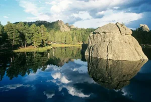
Black Elk Peak, formerly named Harney Peak, with an elevation of 7,242 ft (2,207 m), is the state’s highest point, while the shoreline of Big Stone Lake is the lowest, with an elevation of 966 ft (294 m). South Dakota is bordered to the north by North Dakota; to the south by Nebraska; to the east by Iowa and Minnesota; and to the west by Wyoming and Montana. The geographical center of the U.S. is 17 miles (27 km) west of Castle Rock in Butte County. The North American continental pole of inaccessibility is between Allen and Kyle, 1,024 mi (1,648 km) from the nearest coastline.
The Governor of South Dakota occupies the executive branch of the state government. The current governor at the time of this writing is Kristi Noem, a Republican. The state constitution gives the governor the power to sign into law or veto bills passed by the state legislature, to serve as commander-in-chief of the South Dakota National Guard, to appoint a cabinet, and to commute criminal sentences or to pardon those convicted of crimes. The governor serves for a four-year term, and may not serve more than two consecutive terms.